The objective of this Initiative - to map GI-education in Europe - really is a long distance goal. There is a good side to that: it works like a compass pointing North. Frans Rip from the University of Wageningen in The Netherlands is coordinating the initiative. At the moment, three themes are of great importance: Funding, Publications and Network.
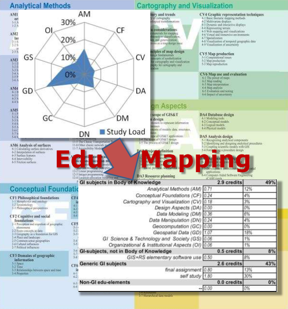
EduMapping, a simple way to quantify the size of subjects in the study load of a curriculum, or one of its components, in terms of the GI Body of Knowledge and ECTS units
Search for funding
In the summer of 2011 after the AGILE conference in Utrecht, a considerable amount of time was spent on constructing a “preliminary proposal” for the COST program. This is a “European instrument supporting cooperation among scientists and researchers across Europe”. Contributors to the proposal were AGILE-members from Germany, Portugal, France, Italy, Greece and the Netherlands. The proposal was submitted on September 30th. Its abstract was: “The proposed action will make teaching about geo-information (GI) in Europe more transparent. This will be beneficial for GI-education, educational quality assurance and for GI-employers. The essence is the introduction of a new method (EduMapping) to characterize GI-teaching courses. EduMapping is based on the GI Science and Technology Body of Knowledge. It results in a label, showing the distribution of study load (ECTS) across 10 Knowledge Areas. Such labels will make GI-courses better comparable between organizations and across national borders. This should help GI-employers to evaluate job applicats. International professional organizations (i.e. ICA, ISPRS, AGILE) are interested in collaboration around EduMapping. The work would be talking to mentioned parties, to create awareness and obtain cooperation. They will also be asked for their wishes for a software tool to query a repository of GI teaching labels. With those a demonstrator shall be constructed and used to get user feedback”.
It was a great stimulus to formulate what we want and how to get there. But it was a struggle. Preparation of the proposal was a tedious process since we had to adhere to various constraints imposed by the submission forms. Unfortunately at the end of November we were notified that our proposal was not accepted. Since in the COST program there are two Open Calls for proposals every year, we took a second chance in March 2012 submitting a modified proposal.
Publications
Another activity in the autumn of 2011 was the writing of three papers and preparation of presentations with relevance to EduMapping for the LeGIO conference organized by Marinus de Bakker (U. Groningen, The Netherlands), Wolfgang Reinhardt (Universität der Bundeswehr, Germany) and Frans Rip. It was held on November 18 at Leuven University, Belgium. In his contribution, Marinus suggested to be more selective in teaching GI-subjects to students. Wolfgang proposed to add two more Knowledge Areas to GI BoK: Spatial Data Infrastructure and Application Programming. The paper of this author was about the differences between the American approach (Body of Knowledge, Geospatial Technology Competency Model) and the European approach (ETCS, Learning Outcomes) and if they might meet. The papers are available online.
In early 2012, in response to the EUGISES Seminar call-for-abstracts, an abstract was composed by Edward Verbree (Delft University, The Netherlands) and Frans Rip about an EduMapping subject. Recently, this proposed contribution was accepted. The paper presents the successful use of the EduMapping method for the redesign of the Geomatics curriculum at Delft University. The EUGISES Seminar will take place in Leuven in the second week of September 2012. There are two additional sources for dissemination of information related to this initiative, the EduMapping website that includes various presentations on EduMapping and BoK and the recently started open LinkedIn Group “EduMapping GI Teaching”. The website intends to be a repository for EduMapping materials (like the EduMapping Kit), whereas the LinkedIn group should become a discussion platform.
Building a network
The website and the LinkedIn group could generate a group of interested people, stakeholders in the process of describing GI teaching. So far, the response is limited, but we do hope that the interest will pick up. In the summer of 2011 there were two meetings with ICA (Int. Cartography Assoc.), ISPRS (Int. Soc. for Photogrammetry and Remote Sensing) and GI S&T Body of Knowledge 2 in Utrecht and Paris. Subject was cooperation in relation to the Body of Knowledge and its second edition. At these meetings every party present said to be on the lookout for funding possibilities. As a low cost follow up of these sessions, the EduMapping Initiative proposed to organize a workshop at the AGILE Conference in Avignon this year. This workshop, titled “Views on the Body of Knowledge”, is expected to bring more clarity about how ICA, ISPRS and others will deal with this knowledge domain reference.
Papers and tool are on http://www.geo-informatie.nl/rip001/edumapping/EduMapping.html
Let's hope that the AGILE members will EduMap their GI curricula by filling in in the Education field at http://agile.gis.geo.tu-dresden.de/web/index.php/community/member
Council: Bénédicte Bucher, Lead: Frans Rip (Wageningen University), Member 1: University Groningen, Other Member: Universidade Nova Lisboa, UniBw Munich, KU Leuven